The SEDRIS Data Representation Model
APPENDIX A - Classes
Property Grid
|
|---|
Class Name: Property Grid
Subclasses
This DRM class is concrete and has no subclasses.
Definition
An instance of this DRM class is a <Data Table> instance
that has at least one but not more than three spatial axes.
Spatial axes shall always appear before any other
<Axis> components in the ordered list of
<Axis> components for the <Property Grid>
instance.
A spatial axis is an <Axis> component that describes
sampling along one of the components of the SRF of
the <Property Grid> instance. Hence, it is directly
useful for locating the sample values in space. To qualify as spatial,
the <Axis> component shall match the SRF
exactly, using a consistent specification (e.g., the same ORM,
direction vector and units). Spatial axes have the following
characteristics.
The spatial <Axis> components of a
<Property Grid> instance shall always be the
first members of the ordered set of <Axis> components.
The spatial_axes_count
field indicates how many of the <Axis> components are
spatial. Because the <Axis> component ordering also determines
the scanning order when data is retrieved from a
<Data Table> instance, placing
the spatial axes first imposes some limitations
on the way data can be scanned.
There are no other ordering rules for
spatial <Axis> components. If a producer has a choice,
it is recommended that spatial <Axis> components
be ordered in the same way as the SRF components. As mentioned in
the previous item, this is not always possible. Thus, no assumptions
can be made about the ordering apart from those
stated above.
Primary Page in DRM Diagram:
Secondary Pages in DRM Diagram:
Example
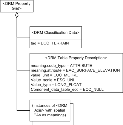
A DTED <Property Grid> instance is associated to
<Areal Feature> instances representing
DTED accuracy areas supplemental to the grid.
Consider a <Property Grid> instance classified
as ECC_WATERBODY_TEMPERATURE_PROPERTY_SET
for an ocean volume. Ocean
temperature features, such as warm/cold currents, fronts,
and eddies, are associated to specific cells of the
<Property Grid> instance.
Consider a transmittal provided by a data producer whose format uses
polygons rather than grids to represent terrain, where the polygons
define a default post spacing. To provide this
default post spacing
in the transmittal, the data provider provides an empty
<Property Grid> instance, attaching it to the
hierarchy with a
<Property Grid Hook Point>
instance, as usual, with the structure depicted in .
The spatial <Axis> instances define the extents and the
spacing of the <Property Grid> instance. The
data provider has the option of providing
<Property Characteristic>
components for the
<Table Property Description>
instance to supply the minimum and maximum elevation values.
FAQs
-
Since <Property Grid> is a subclass
of <Data Table>, and a
<Data Table Library> instance is composed of
<Data Table> instances, doesn't that mean
that a <Property Grid> instance can be a
component of a
<Data Table Library> instance?
Yes.
-
What are examples of non-spatial axes?
Any <Axis> instance for which the
axis_type is not spatial is a
non-spatial <Axis> instance. Examples of such
axis_type values are
EAC_MONTH,
material index,
EAC_DENSITY.
There are also <Axis> instances that
seem to have spatial meaning but are not "spatial" to the DRM,
for example, atmospheric pressure height, height above or below terrain
surface, azimuth. These are non-spatial to SEDRIS because they require
either additional information (such as the location of the terrain surface)
or a parametric formula (such as the standard atmosphere model) to convert
their values into a <Location> instance in the
SRF of the
<Property Grid> instance.
-
Why is a <Property Table> instance permitted
to have other <Data Table> instances as components?
This mechanism allows a <Property Grid>
instance's cell data element to specify an index into the set of ordered
<Data Table> components, so that any
<Data Table> component can be referenced by many
data cells. See <<Index Codes within Tables>> for further details.
-
Why is a <Property Grid> instance allowed to
associate directly with a
<Feature Representation> instance?
Couldn't the same functionality be achieved by associating the
<Feature Representation> instance
with a
<Property Grid Hook Point>
instance?
No. A <Property Grid Hook Point>
instance may have several
<Property Grid> components,
making the main connection between a
<Feature Representation> instance
and a <Property Grid> instance ambiguous.
-
What if a cell in a <Property Grid> instance
is related to several
<Feature Representation> instances
simultaneously?
This is easily handled by having the cell index to a (nested)
<Data Table> component of related
<Feature Representation> instance IDs
(EAC_NUMERIC_OBJECT_IDENTIFIER).
Such <Data Table> components of related
<Feature Representation> instances
shall be classified as
ECC_RELATED_OBJECT_SET.
-
What is the point of having an "empty"
<Property Grid> instance, that is, with
data_present =
SE_FALSE?
Because it provides an outline or template of the
<Property Grid> instance's information by
providing the size, orientation, spacing, and so on of the
<Property Grid> instance without any
cell values.
This makes it possible, for instance, for a consumer who requires
<Property Grid> instances rather than
<Polygon> instances for terrain to derive the
<Property Grid> representation from the
<Polygon> representation (see example 3).
Constraints
Associated to (one-way)
Associated by (one-way)
Composed of (two-way) (inherited)
Composed of (two-way)
Composed of (two-way metadata) (inherited)
Component of (two-way) (inherited)
Component of (two-way)
Inherited Field Elements
This class has no inherited field elements.
Notes
Associated to Notes
An association between a
<Property Grid> instance and a
<Feature Representation> instance
indicates that the environmental object(s) represented by the
<Feature Representation> instance
and the <Property Grid> instance
(or some specific cell data within that
<Property Grid> instance) have the
semantic relationship indicated by the
<Base Association Data> link object
on the association relationship. Each associated
<Property Grid> instance indicates
whether the entire <Property Grid>
instance or only some specific cell data within it is participating
in the relationship in question.
Associated from Notes
An association between a
<Property Grid> instance and a
<Feature Representation> instance
indicates that the environmental object(s) represented by the
<Feature Representation> instance
and the <Property Grid> instance
(or some specific cell data within that
<Property Grid> instance) have the
semantic relationship indicated by the
<Base Association Data> link object
on the association relationship. Each associated
<Property Grid> instance indicates
whether the entire <Property Grid>
instance or only some specific cell data within it is participating
in the relationship in question.
Composed of Notes
The <Classification Data>
component indicates the kind of information represented by the
<Data Table> instance, such as terrain elevation or
water characteristics.
Fields Notes
The spatial_axes_count
field specifies how many axes of the
<Property Grid> instance
are spatial axes.
The location_index field specifies
up to three grid indexes that identify the grid cell
that contains the location corresponding to that specified by the
<Location 3D> component of the
<Property Grid Hook Point>
aggregate of the
<Property Grid> instance.
The identified cell is where the <Location 3D>
instance is attached to the
<Property Grid> instance.
The location_index
shall specify a valid cell within the
<Property Grid> instance;
that is, the indexes shall be within the appropriate bounds of
the <Property Grid> instance. Only
the first
spatial_axes_count
entries of location_index
are significant.
The srf_info field specifies
the SRF within which the <Property Grid> instance is defined.
The griddedness of spatial positions is dependent on the properties of
the SRF. Coordinate conversions and transformations are not, in general,
linear, so that a set of points that form a regular array of positions
in one SRF may not be regular in another SRF. Therefore,
in order to preserve griddedness, a
<Property Grid> instance
specifies an SRF in which the data positions form a grid.
If data_present =
SE_TRUE (the default), the
<Property Grid>
instance contains cell values that can be extracted by invoking the
appropriate API functions.
Otherwise, if data_present
= SE_FALSE, the
<Property Grid>
instance does not contain any cell values although it may provide
everything else that a populated
<Property Grid> instance can provide.
Prev: Property Description.
Next: Property Grid Hook Point.
Up:Index.
|
Last updated: August 23, 2005
|
Copyright © 2005 SEDRIS™
|
|