 SEDRIS Spatial Reference Model |
 SRM Tutorial |
 Outline |
 Section I |
 In the Beginning ... |
 Simulation Interfaces |
 A Spectrum of Constructive, Live and Virtual Capabilities Support Training, Planning & Analysis |
 A Spectrum of Constructive, Live and Virtual Capabilities Support Training, Planning & Analysis |
 The Interface Canyons |
 Why is a Spatial Reference Model (SRM) Needed? |
 SRM Requirements |
 Location is Not Enough |
 A Shared Solution is Required! |
 Section II |
 It�s a Loooong Way Up |
 Here�s an Interesting Perspective |
 Not All Projections are Geodetic! |
 More Familiar? |
 Spatial, the Final Frontier |
 Coordinates |
 DRM <Location> (Page 15) |
 Spatial Reference Frames |
 SRF Example |
 Named SRFs in SEDRIS |
 Named SRFs in SEDRIS |
 Coordinates & Coordinate Systems |
 ERMs |
 Standard Ellipsoids |
 Standard Spheres |
 Standard Horizontal Datums |
 Standard Vertical Datums |
 ORMs |
 Many SRFs |
 Spatial Reference Model |
 Operations on Coordinates |
 Types of Operation Errors |
 Section IIB |
 Ellipsoidal Earth Reference Model (ERM) Geometry & Notation |
 Latitude, Longitude and Height for Ellipsoids & Spheres |
 Cross-Section of the Geoid, Ellipsoid and Earth Surface |
 Gravitational Field and the Geoid, Ellipsoid & Earth Surface |
 SRM Refresher |
 Section III |
 Development of Surfaces to Generate Maps |
 Map Projections |
 Projecting from 2D to 1D |
 Cylindrical Projections |
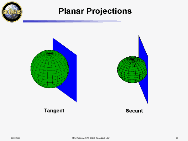 Planar Projections |
 A Stereographic Projection |
 Conic Projections |
 Mercator Projection |
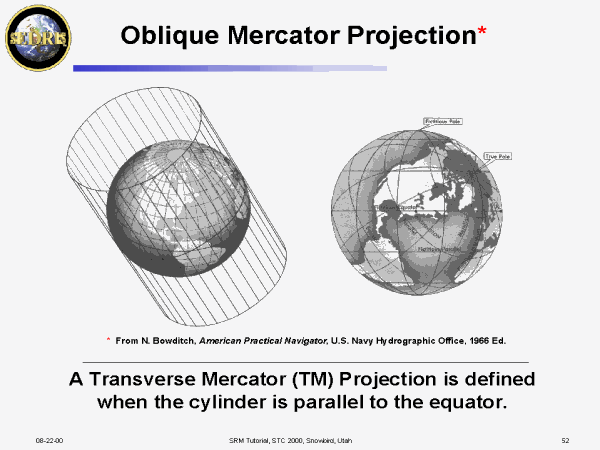 Oblique Mercator Projection* |
 Transverse Mercator Map of the Western Hemisphere* |
 Universal Transverse Mercator (60) |
 Lines of Constant Heading* |
 Great Circle Arc between Moscow and Washington D.C.* |
 Many Map Projections are Conformal |
 Section IV |
 Augmented Projection-Based SRFs |
 �3D� Projection-based SRFs |
 Coordinate Operations affect Geometrical Relationships |
 SRF Operation Relationships |
 Geometric Distortions |
 Distance and Elevation Angle |
 Distance Distortion Can Be Mitigated, Somewhat |
 Azimuth |
 How Much Azimuth Distortion? |
 Flattening the ERM: Distance and Geometry |
 Section V |
 Modelers Often Prefer Cartesian Coordinate Frameworks |
 Non-real World 3-D Systems are often Used. Why ? |
 Relationships Between Coordinate Systems and Simulations |
 MCG&I and Dynamics Modeling |
 MCG&I |
 Dynamics Modeling |
 Section VI |
 Euclidean Distance in a Rectangular Framework |
 Defining Geometrical Concepts |
 The Traditional Surveying Process |
 Surveying is a Complex Process |
 Traditional Distance Determination in Surveys |
 Surveying on a Flat ERM |
 Surveying on a Flat ERM with a Terrain Model Added |
 Surveying on a Spherical ERM |
 Chaining on a Spherical ERM with a Terrain Model Added |
 Surveying on an Ellipsoidal ERM |
 Normal Section of an Ellipsoid |
 Distance on an Ellipsoidal ERM |
 Bearing Angles (Ellipsoidal ERM) |
 Bearing when a Point P is above the ERM Surface (Ellipsoid) |
 Once the Environment is Included, There are Many Feasible Paths |
 Placing a Solid Cube on an ERM |
 Doing the Math ... |
 Placing a Cube on the Terrain Skin Model |
 Long Linear Structures |
 Vectors in Augmented Projection-based SRFs |
 Vectors in a Curvilinear System |
 Defining a Canonical Local Tangent Plane SRF |
 A LTP Embedded in a GD SRF |
 Defining a CLTP Embedded in a GD SRF |
 Reference Vectors |
 Reference Vector Transformations |
 SRF �North� may not be True North |
 Convergence of the Meridian |
 Representing a Projection-based SRF Vector in Terms of a CLTP |
 TM series for X and Y (from P. D. Thomas) |
 Computing the Convergence of the Meridian (COM) |
 Second Method for Computing the COM |
 Computing the Sine and Cosine of the COM |
 Observations |
 Section VII |
 Why is Accuracy Needed for Coordinate Transformations? |
 Shooting at a Target in the Real World (Relative Coordinate System) |
 Simulation of Shooting at a Target (Simulation of a Relative Coordinate System) |
 Error Sources in Coordinate Transformation Software |
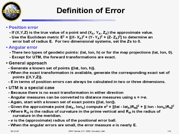 Definition of Error |
 Numerical methods |
 Efficient Evaluation of Special Functions Common to Coordinate Transformations |
 Analytic (closed form) Solutions |
 Taylor/Maclaurin Series Methods |
 Iterative Methods |
 Direct Approximation of a Function or its Inverse |
 Error in Power Series Expansions |
 Authoritative Sources Sometimes Appear to Disagree |
 Error Analysis and Resolution of Disagreements |
 Effect of Small Errors |
 Fuzzy Creep/Coordinate Drift |
 Bounds Checking |
 What to Do? |
 Distortion and Computation Error Tradeoff |
 Distortion in Projection-based SRFs |
 Distortion-Accuracy Trades for UTM |
 Point Scale Equations |
 UTM Point Scale Equations |
 Linear Distortion Error For UTM |
 Difference between SR-7 & Extended Formulas for Transverse Mercator |
 Conclusions of Experiment |
 The Chaining Problem |
 Section VIII |
 SRFs |
 DRM <Location> (Page 15) |
 SRFs Supported |
 SRFs with CS Origin Offsets* |
 Local Space Rectangular |
 Local Space Rectangular (2D) |
 Geocentric |
 Geodetic |
 Geodetic (2D) |
 Local Tangent Plane |
 Local Tangent Plane (2D) |
 GCS |
 Mercator |
 Augmented Mercator |
 Oblique Mercator |
 Augm. Oblique Mercator |
 Transverse Mercator |
 Augm. Transverse Mercator |
 Universal Transverse Mercator |
 Augm. Univ. Transverse Mercator |
 Lambert Conformal Conic |
 Augm. Lambert Conformal Conic |
 Polar Stereographic |
 Augm. Polar Stereographic |
 Universal Polar Stereographic |
 Augm. Univ. Polar Stereographic |
 Equidistant Cylindrical |
 Augm. Equidistant Cylindrical |
 Geocentric Equatorial Inertial |
 Geomagnetic |
 Geocentric Solar Ecliptic |
 Geocentric Solar Magnetic |
 Solar Magnetic |
 Section IX |
 PPT Slide |
 ERM Datum Transformations |
 Init WGS84 Geoidal Separation |
 Get WGS84 Geoidal Separation |
 PPT Slide |
 Types of Operation Errors |
 �Valid� Coordinates |
 Coordinate Validity |
 Implementation Details (1 of 2) |
 Implementation Details (2 of 2) |
 Range Extension (1 of 2) |
 Range Extension (2 of 2) |
 PPT Slide |
 Op Support |
 Coordinate Operation Chains |
 Status Codes (1 of 3) |
 Status Codes (2 of 3) |
 Status Codes (3 of 3) |
 Interface Specification(s) |
 Operation Setup |
 Conversion Operation |
 Multi-conversion Operation |
 Boundary Checking |
 Operation Teardown |
 Vector Operation |
 Matrix Operation* |
 Transformation Operation |
 Convergence of Meridian Operation |
 �SRM Check Utility�* |
 Further Reading |
. |